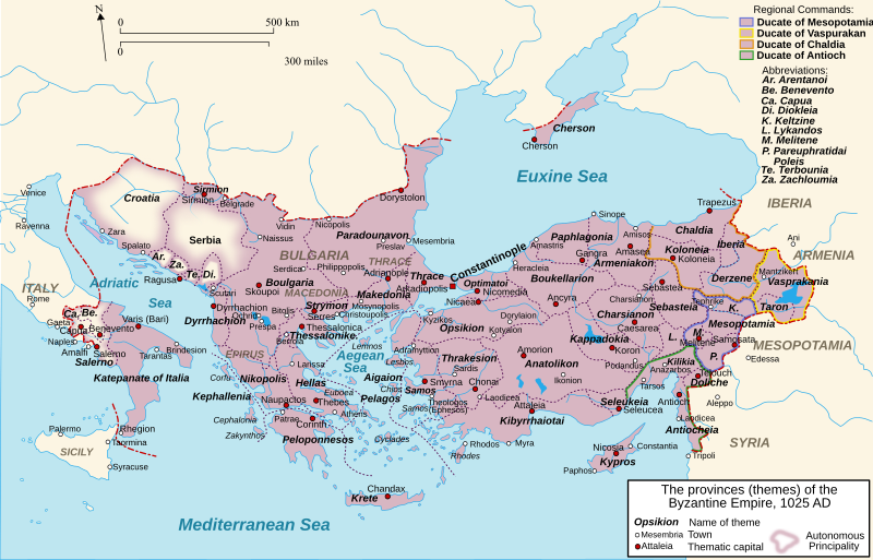
File:Byzantine Empire Themes 1025-en.svg
外观

此SVG文件的PNG预览的大小:800 × 512像素。 其他分辨率:320 × 205像素 | 640 × 410像素 | 1,024 × 656像素 | 1,280 × 819像素 | 2,560 × 1,639像素 | 1,840 × 1,178像素。
原始文件 (SVG文件,尺寸为1,840 × 1,178像素,文件大小:485 KB)
文件历史
点击某个日期/时间查看对应时刻的文件。
| 日期/时间 | 缩略图 | 大小 | 用户 | 备注 | |
|---|---|---|---|---|---|
| 当前 | 2024年12月27日 (五) 11:09 |  | 1,840 × 1,178(485 KB) | Leptictidium | File uploaded using svgtranslate tool (https://svgtranslate.toolforge.org/). Added translation for ca. |
| 2024年4月22日 (一) 21:16 |  | 1,840 × 1,178(485 KB) | Leptictidium | File uploaded using svgtranslate tool (https://svgtranslate.toolforge.org/). Added translation for ca. | |
| 2024年4月22日 (一) 09:22 |  | 1,840 × 1,178(485 KB) | Leptictidium | File uploaded using svgtranslate tool (https://svgtranslate.toolforge.org/). Added translation for ca. | |
| 2024年4月22日 (一) 09:14 |  | 1,840 × 1,178(485 KB) | Leptictidium | File uploaded using svgtranslate tool (https://svgtranslate.toolforge.org/). Added translation for ca. | |
| 2024年4月21日 (日) 07:45 |  | 1,840 × 1,178(485 KB) | Leptictidium | File uploaded using svgtranslate tool (https://svgtranslate.toolforge.org/). Added translation for ca. | |
| 2024年2月11日 (日) 16:10 |  | 1,840 × 1,178(485 KB) | Manlleus | File uploaded using svgtranslate tool (https://svgtranslate.toolforge.org/). Added translation for ca. | |
| 2024年2月9日 (五) 22:53 |  | 1,840 × 1,178(485 KB) | Manlleus | added catalan language | |
| 2024年2月9日 (五) 21:41 |  | 1,840 × 1,178(354 KB) | Manlleus | fixed some tspan issues | |
| 2012年12月28日 (五) 22:32 |  | 1,840 × 1,178(354 KB) | Dipa1965 | Added 3 lakes in Asia Minor and 2 in Balkans. Removed most groupings, in order to facilitate future translations. Further code cleanup. See Discussion for changes in historical data. | |
| 2012年10月15日 (一) 22:18 |  | 1,840 × 1,178(345 KB) | Dipa 1965 | Corrections of borders of quite a few northwest Balkan territories (Croatia, Arentanoi, Zachloumia, Terbounia, Diokleia). See Discussion upf=date for details and references. |
文件用途
没有页面链接到本图像。
全域文件用途
以下其他wiki使用此文件:
- ar.wikipedia.org上的用途
- az.wikipedia.org上的用途
- bs.wikipedia.org上的用途
- ca.wikipedia.org上的用途
- cs.wikipedia.org上的用途
- de.wikipedia.org上的用途
- el.wikipedia.org上的用途
- en-two.iwiki.icu上的用途
- Samuel of Bulgaria
- Theme (Byzantine district)
- Constantine Bodin
- Gojslav
- Stephen I of Croatia
- Krešimir III
- Basil Boioannes
- Iberia (theme)
- Byzantine Empire under the Macedonian dynasty
- Bulgaria (theme)
- Wikipedia talk:WikiProject Greece/Archive 3
- History of the Byzantine Empire
- Katepano
- User:Cplakidas/Sandbox/Byzantine1
- Leo Tornikios
- Ancient regions of Anatolia
- Talk:Kingdom of Croatia (925–1102)/Archive 1
- Timeline of Eastern Orthodoxy in Greece (717–1204)
- User:Falcaorib/Medieval Empires (1000-1100 AD)
- es.wikipedia.org上的用途
- et.wikipedia.org上的用途
- fi.wikipedia.org上的用途
- fr.wikipedia.org上的用途
查看此文件的更多全域用途。


