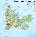
File:Kerguelen topographic map-fr.svg
外观

此SVG文件的PNG预览的大小:576 × 599像素。 其他分辨率:231 × 240像素 | 461 × 480像素 | 738 × 768像素 | 984 × 1,024像素 | 1,968 × 2,048像素 | 1,840 × 1,915像素。
原始文件 (SVG文件,尺寸为1,840 × 1,915像素,文件大小:2.33 MB)
文件历史
点击某个日期/时间查看对应时刻的文件。
| 日期/时间 | 缩略图 | 大小 | 用户 | 备注 | |
|---|---|---|---|---|---|
| 当前 | 2010年4月25日 (日) 14:12 |  | 1,840 × 1,915(2.33 MB) | Korrigan | Correcting roads after advice from B.navez |
| 2009年3月17日 (二) 21:02 |  | 1,840 × 1,915(2.33 MB) | Korrigan | Typo ("prequ'île") | |
| 2009年3月17日 (二) 19:46 |  | 1,840 × 1,915(2.33 MB) | Korrigan | {{Information |Description={{en|Topographic map of the Kerguelen Islands, Indian Ocean, France. Use the PNG version for inserting into articles as it is lighter.}} {{fr|Carte topographique des îles Kerguelen. Ut |
文件用途
全域文件用途
以下其他wiki使用此文件:
- af.wikipedia.org上的用途
- cs.wikipedia.org上的用途
- en-two.iwiki.icu上的用途
- fr.wikipedia.org上的用途
- hr.wikipedia.org上的用途
- it.wikipedia.org上的用途
- nl.wikipedia.org上的用途
- nn.wikipedia.org上的用途
- pl.wikipedia.org上的用途
- uk.wikipedia.org上的用途
- vi.wikipedia.org上的用途


