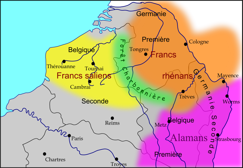
File:Les Francs en Belgique romaine.svg
外观

此SVG文件的PNG预览的大小:800 × 552像素。 其他分辨率:320 × 221像素 | 640 × 442像素 | 1,024 × 706像素 | 1,280 × 883像素 | 2,560 × 1,766像素。
原始文件 (SVG文件,尺寸为1,280 × 883像素,文件大小:353 KB)
文件历史
点击某个日期/时间查看对应时刻的文件。
| 日期/时间 | 缩略图 | 大小 | 用户 | 备注 | |
|---|---|---|---|---|---|
| 当前 | 2009年11月15日 (日) 10:03 |  | 1,280 × 883(353 KB) | Odejea | Correction des frontières alamanes en fonction de cette carte |
| 2009年11月15日 (日) 09:02 |  | 1,280 × 883(352 KB) | Odejea | correction des limites du territoire des francs rhénans | |
| 2009年11月14日 (六) 13:14 |  | 1,280 × 883(352 KB) | Odejea | Ajout des noms des peuples barbares | |
| 2009年11月13日 (五) 22:46 |  | 1,275 × 880(308 KB) | Odejea | {{Information |Description={{fr|1=Carte des royaumes Francs et Alamans dans le nord de l'ancienne Gaule romaine}} |Source={{own}} |Author=Odejea |Date=13 novembre 2009 |Permission= |other_versions= }} [[Category:Maps showing history of th |
文件用途
以下页面使用本文件:
全域文件用途
以下其他wiki使用此文件:
- an.wikipedia.org上的用途
- be.wikipedia.org上的用途
- bg.wikipedia.org上的用途
- ca.wikipedia.org上的用途
- en-two.iwiki.icu上的用途
- en.wiktionary.org上的用途
- fr.wikipedia.org上的用途
- fr.wikivoyage.org上的用途
- la.wikipedia.org上的用途
- lt.wikipedia.org上的用途
- mk.wikipedia.org上的用途
- nl.wikipedia.org上的用途
- nn.wikipedia.org上的用途
- pt.wikipedia.org上的用途
- ru.wikipedia.org上的用途
- sl.wikipedia.org上的用途
- uk.wikipedia.org上的用途


