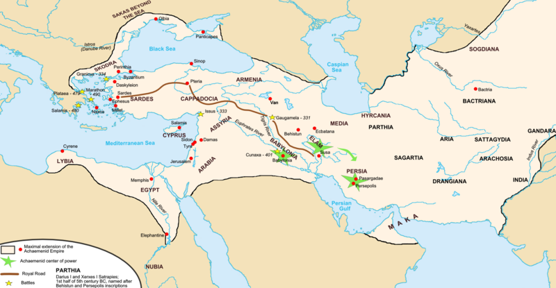
File:Map achaemenid empire en.png
外观

本预览的尺寸:800 × 415像素。 其他分辨率:320 × 166像素 | 640 × 332像素 | 1,024 × 531像素 | 1,676 × 869像素。
原始文件 (1,676 × 869像素,文件大小:376 KB,MIME类型:image/png)
文件历史
点击某个日期/时间查看对应时刻的文件。
| 日期/时间 | 缩略图 | 大小 | 用户 | 备注 | |
|---|---|---|---|---|---|
| 当前 | 2017年11月19日 (日) 04:35 |  | 1,676 × 869(376 KB) | R9tgokunks | Reverted to version as of 00:35, 14 October 2015 (UTC) |
| 2017年10月24日 (二) 08:36 |  | 1,676 × 869(450 KB) | Mehrdad 12 | Reverted to version as of 21:38, 10 August 2015 (UTC) | |
| 2015年10月14日 (三) 00:35 |  | 1,676 × 869(376 KB) | LouisAragon | For the last time; they did NOT conquer territoiry past the Indus River border as of on this map. | |
| 2015年10月12日 (一) 00:02 |  | 1,676 × 864(484 KB) | History of Persia | Macedonia | |
| 2015年10月11日 (日) 23:58 |  | 1,676 × 869(446 KB) | History of Persia | Yeah their included but the borders are innacurrate. Arabia extended deeper and the indus river itself was not the border itself. | |
| 2015年10月11日 (日) 02:33 |  | 1,676 × 869(376 KB) | LouisAragon | The Indus and Northern Arabia are already included. Bring your concerns (with sources) to the Wikipedia talk page. | |
| 2015年8月14日 (五) 04:45 |  | 1,676 × 869(446 KB) | History of Persia | better | |
| 2015年8月10日 (一) 21:38 |  | 1,676 × 869(450 KB) | History of Persia | darius conquered the indus and arabia | |
| 2015年8月10日 (一) 21:38 |  | 1,676 × 869(450 KB) | History of Persia | darius conquered the indus and arabia | |
| 2015年8月10日 (一) 21:37 |  | 1,676 × 869(450 KB) | History of Persia | darius conquered the indus and arabia |
文件用途
以下6个页面使用本文件:
全域文件用途
以下其他wiki使用此文件:
- als.wikipedia.org上的用途
- ar.wikipedia.org上的用途
- arz.wikipedia.org上的用途
- ast.wikipedia.org上的用途
- av.wikipedia.org上的用途
- azb.wikipedia.org上的用途
- az.wikipedia.org上的用途
- ba.wikipedia.org上的用途
- be.wikipedia.org上的用途
- bg.wikipedia.org上的用途
- bs.wikipedia.org上的用途
- bxr.wikipedia.org上的用途
- cs.wikipedia.org上的用途
- de.wikipedia.org上的用途
- diq.wikipedia.org上的用途
- el.wikipedia.org上的用途
- en-two.iwiki.icu上的用途
- Empire
- Talk:Iran/Archive 10
- Timeline of Jerusalem
- List of conflicts in Asia
- User talk:SG/Archive1
- Template talk:History of Afghanistan
- File talk:Map achaemenid empire en.png
- User:Ottava Rima/Persian Empire
- User:John K/Persian Empire
- Talk:Achaemenid Empire/Archive 1
- List of ancient great powers
- Wikipedia:Graphics Lab/Map workshop/Archive/Mar 2020
- User:Falcaorib/Ancient Empires (550-300 BC)
- User:Falcaorib/Iran
- en.wikibooks.org上的用途
- en.wiktionary.org上的用途
- eo.wikipedia.org上的用途
- es.wikipedia.org上的用途
- eu.wikipedia.org上的用途
查看此文件的更多全域用途。


