
File:Map of North America with the Western Interior Seaway during the Campanian (Upper Cretaceous).png

本预览的尺寸:488 × 600像素。 其他分辨率:195 × 240像素 | 390 × 480像素 | 625 × 768像素 | 833 × 1,024像素 | 1,945 × 2,391像素。
原始文件 (1,945 × 2,391像素,文件大小:3.95 MB,MIME类型:image/png)
.png?uselang=zh)
.png?uselang=zh)
.png?action=history&uselang=zh)
.png)
摘要
| 描述 |
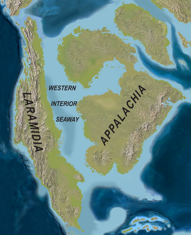
English: Map of North America with the Western Interior Seaway during the Campanian (Upper Cretaceous). Paleogeography of North America during the late Campanian Stage of the Late Cretaceous (∼75 Ma). Modified after Blakey.
Deutsch: Karte von Nordamerika mit dem Western Interior Seaway während des Campaniums (Obere Kreide) |
| 日期 | |
| 来源 | http://www.plosone.org/article/info%3Adoi%2F10.1371%2Fjournal.pone.0012292 |
| 作者 | Scott D. Sampson, Mark A. Loewen, Andrew A. Farke, Eric M. Roberts, Catherine A. Forster, Joshua A. Smith, Alan L. Titus |
| 授权 (二次使用本文件) |
http://www.plosbiology.org/static/license.action |
许可协议
文件历史
点击某个日期/时间查看对应时刻的文件。
| 日期/时间 | 缩略图 | 大小 | 用户 | 备注 | |
|---|---|---|---|---|---|
| 当前 | 2020年4月1日 (三) 21:08 | | 1,945 × 2,391(3.95 MB) | FunkMonk | {{Information |Description = {{en|1=Map of North America with the Western Interior Seaway during the Campanian (Upper Cretaceous). Paleogeography of North America during the late Campanian Stage of the Late Cretaceous (∼75 Ma). Modified after Blakey.}} {{de|1=Karte von Nordamerika mit dem Western Interior Seaway während des Campaniums (Obere Kreide)}} |Source =http://www.plosone.org/article/info%3Adoi%2F10.1371%2Fjournal.pone.0012292 |Author =Scott D. Sampson, Mark A. Loewe... |
文件用途
全域文件用途
以下其他wiki使用此文件:
- de.wiktionary.org上的用途
- en-two.iwiki.icu上的用途
- fa.wikipedia.org上的用途
- fr.wikipedia.org上的用途
- id.wikipedia.org上的用途
- it.wikipedia.org上的用途
- ja-two.iwiki.icu上的用途
- ne.wikipedia.org上的用途
- nl.wikipedia.org上的用途
- pl.wikipedia.org上的用途
- pl.wiktionary.org上的用途
- pt.wikipedia.org上的用途
- ru.wikipedia.org上的用途
- tr.wikipedia.org上的用途
- uk.wikipedia.org上的用途
.png)