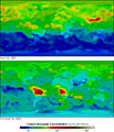
File:Mopitt first year carbon monoxide.jpg
外观

本预览的尺寸:514 × 600像素。 其他分辨率:206 × 240像素 | 540 × 630像素。
原始文件 (540 × 630像素,文件大小:61 KB,MIME类型:image/jpeg)
文件历史
点击某个日期/时间查看对应时刻的文件。
| 日期/时间 | 缩略图 | 大小 | 用户 | 备注 | |
|---|---|---|---|---|---|
| 当前 | 2005年5月18日 (三) 10:30 |  | 540 × 630(61 KB) | ChVA | From english Wikipedia The MOPITT sensor aboard NASA’s Terra satellite has assembled the first view of carbon monoxide in the Earth's atmosphere. The false colors represent levels of carbon monoxide in the lower atmosphere, ranging from about 390 part |
文件用途
以下页面使用本文件:
全域文件用途
以下其他wiki使用此文件:
- ar.wikipedia.org上的用途
- az.wikipedia.org上的用途
- bn.wikipedia.org上的用途
- cs.wikipedia.org上的用途
- cs.wikibooks.org上的用途
- el.wikipedia.org上的用途
- en-two.iwiki.icu上的用途
- fa.wikipedia.org上的用途
- fr.wikipedia.org上的用途
- gl.wikipedia.org上的用途
- gu.wikipedia.org上的用途
- ha.wikipedia.org上的用途
- hy.wikipedia.org上的用途
- id.wikipedia.org上的用途
- ml.wikipedia.org上的用途
- nds.wikipedia.org上的用途
- pt.wikipedia.org上的用途
- ro.wikipedia.org上的用途
- ru.wikipedia.org上的用途
- sh.wikipedia.org上的用途
- sk.wikipedia.org上的用途
- sl.wikipedia.org上的用途
- sr.wikipedia.org上的用途
- ta.wikipedia.org上的用途
- te.wikipedia.org上的用途
- th.wikipedia.org上的用途
- vi.wikipedia.org上的用途


