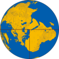
File:Orthographic T&O.png
外观

本预览的尺寸:600 × 600像素。 其他分辨率:240 × 240像素 | 480 × 480像素 | 768 × 768像素 | 1,024 × 1,024像素 | 1,806 × 1,806像素。
原始文件 (1,806 × 1,806像素,文件大小:863 KB,MIME类型:image/png)
文件历史
点击某个日期/时间查看对应时刻的文件。
| 日期/时间 | 缩略图 | 大小 | 用户 | 备注 | |
|---|---|---|---|---|---|
| 当前 | 2006年1月19日 (四) 20:04 |  | 1,806 × 1,806(863 KB) | Foobaz | An orthographic map centered on jerusalem with east pointing up. Made for the T and O map article, since those maps were also drawn this way. I created a map with http://www.aquarius.geomar.de/omc/ and edited it in GraphicConverter. |
文件用途
以下页面使用本文件:
全域文件用途
以下其他wiki使用此文件:
- cs.wikipedia.org上的用途
- en-two.iwiki.icu上的用途
- es.wikipedia.org上的用途
- fi.wikipedia.org上的用途
- fr.wikipedia.org上的用途
- gl.wikipedia.org上的用途
- he.wikipedia.org上的用途
- it.wikipedia.org上的用途
- ja-two.iwiki.icu上的用途
- ms.wikipedia.org上的用途
- sv.wikipedia.org上的用途
- th.wikipedia.org上的用途
- uk.wikipedia.org上的用途

