
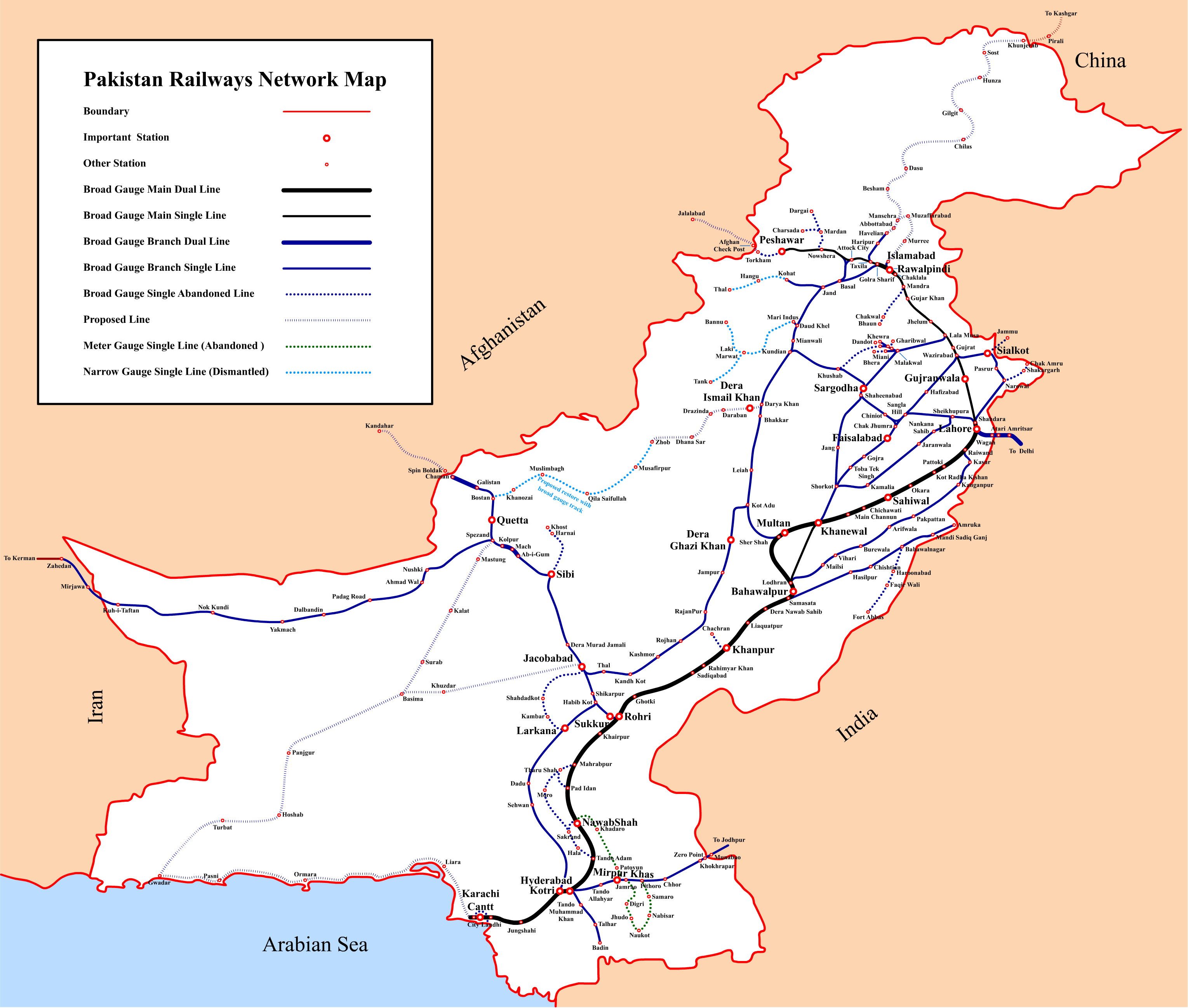
File:Pakistan Railways Network Map.png
本预览的尺寸:707 × 600像素。 其他分辨率:283 × 240像素 | 566 × 480像素 | 905 × 768像素 | 1,207 × 1,024像素 | 2,414 × 2,048像素 | 3,059 × 2,595像素。
原始文件 (3,059 × 2,595像素,文件大小:648 KB,MIME类型:image/png)
文件历史
点击某个日期/时间查看对应时刻的文件。
| 日期/时间 | 缩略图 | 大小 | 用户 | 备注 | |
|---|---|---|---|---|---|
| 当前 | 2016年9月3日 (六) 17:49 | | 3,059 × 2,595(648 KB) | Adnanleon | Updated Karachi-Lahore dual railway track, Added Karachi-Gwadar, Islamabad-Muzaffarabad and Basima-Jacobabad proposed railway lines. |
| 2014年1月27日 (一) 11:44 |  | 3,032 × 2,572(591 KB) | RaviC | + Jammu link | |
| 2013年7月31日 (三) 20:54 |  | 3,032 × 2,572(628 KB) | Adnanleon | Fill white color in center | |
| 2013年7月31日 (三) 20:27 |  | 3,032 × 2,572(560 KB) | Adnanleon | Correction in Sahiwal-Raiwind section and Pak-China proposed railway line | |
| 2012年3月1日 (四) 08:27 |  | 3,042 × 2,557(517 KB) | Nomi887 | Added colour (reason: to make map prominent) | |
| 2012年2月28日 (二) 22:21 |  | 3,042 × 2,557(585 KB) | Sven Manguard | Removing time and author from image. This is *NOT* the version sent by OTRS, that one is immediately below. | |
| 2012年2月28日 (二) 22:12 |  | 3,042 × 2,557(595 KB) | Sven Manguard | Update sent via OTRS photosubmissions | |
| 2011年11月22日 (二) 18:55 |  | 3,010 × 2,540(466 KB) | Adnanleon |
文件用途
全域文件用途
以下其他wiki使用此文件:
- bn.wikipedia.org上的用途
- de.wikipedia.org上的用途
- de.wikivoyage.org上的用途
- en-two.iwiki.icu上的用途
- en.wikivoyage.org上的用途
- eo.wikipedia.org上的用途
- fr.wikipedia.org上的用途
- hi.wikipedia.org上的用途
- hu.wikipedia.org上的用途
- it.wikivoyage.org上的用途
- ja-two.iwiki.icu上的用途
- mr.wikipedia.org上的用途
- pl.wikipedia.org上的用途
- pnb.wikipedia.org上的用途
查看此文件的更多全域用途。