跳转到内容

英文维基 | 中文维基 | 日文维基 | 草榴社区

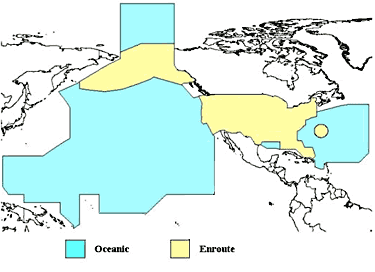
File:US Overflight Fee Map.png

页面内容不支持其他语言。
這個文件來自維基共享資源
维基百科,自由的百科全书

US_Overflight_Fee_Map.png (375 × 272像素,文件大小:28 KB,MIME类型:image/png


摘要

描述
English: A map of the regions where the United States charges overflight fees. Yellow is where higher "enroute" fees are charged. Blue is where "oceanic" fees are charged. The colored regions of this map correspond to the regions where the US has delegated authority by the ICAO to control air traffic, including over international waters.
日期 未知日期
来源 http://www.faa.gov/about/office_org/headquarters_offices/aba/overflight_fees/
作者 Federal Aviation Administration

许可协议

Public domain
本图像或文件是美国联邦航空管理局的雇员基于其个人公务目的制作的作品。作为美国联邦政府作品,本图像或文件在美国属于公有领域

English | italiano | македонски | മലയാളം | Nederlands | русский | sicilianu | українська | 中文 | +/−

文件历史

点击某个日期/时间查看对应时刻的文件。

日期/时间缩⁠略⁠图大小用户备注
当前2014年8月9日 (六) 02:522014年8月9日 (六) 02:52版本的缩略图375 × 272(28 KB)AHeneenUser created page with UploadWizard

以下页面使用本文件:

全域文件用途

元数据