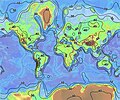
File:World relief map with isopachs of crustal thickness.jpg
外观
World_relief_map_with_isopachs_of_crustal_thickness.jpg (636 × 532像素,文件大小:86 KB,MIME类型:image/jpeg)
文件历史
点击某个日期/时间查看对应时刻的文件。
| 日期/时间 | 缩略图 | 大小 | 用户 | 备注 | |
|---|---|---|---|---|---|
| 当前 | 2011年5月24日 (二) 19:34 |  | 636 × 532(86 KB) | HVL | Reverted to version as of 19:48, 24 January 2007 |
| 2011年5月24日 (二) 17:40 | 500 × 200(140 KB) | Realmau | |||
| 2007年1月24日 (三) 19:48 |  | 636 × 532(86 KB) | Bryan | Reverted to earlier revision | |
| 2007年1月24日 (三) 19:48 |  | 636 × 532(86 KB) | Luna90~commonswiki | Invertit amb una revisió anterior | |
| 2007年1月24日 (三) 19:47 |  | 159 × 160(4 KB) | Luna90~commonswiki | Topo-animal | |
| 2007年1月24日 (三) 19:46 |  | 636 × 532(86 KB) | Luna90~commonswiki | Invertit amb una revisió anterior | |
| 2007年1月24日 (三) 19:45 |  | 159 × 160(4 KB) | Luna90~commonswiki | Topo-animal | |
| 2006年7月18日 (二) 22:00 |  | 636 × 532(86 KB) | Zimbres | {{Information |Description= A contour map of the thickness of the Earth's crust. |Source=http://quake.wr.usgs.gov/research/structure/CrustalStructure/abstract.html |Date= |Author= USGS/USGov |Permission=Free for all use |other_versions= }} [[Category:Tec |
文件用途
以下页面使用本文件:
全域文件用途
以下其他wiki使用此文件:
- af.wikipedia.org上的用途
- ar.wikipedia.org上的用途
- az.wikipedia.org上的用途
- bg.wikipedia.org上的用途
- bh.wikipedia.org上的用途
- ca.wikipedia.org上的用途
- de.wikipedia.org上的用途
- en-two.iwiki.icu上的用途
- en.wikiversity.org上的用途
- es.wikipedia.org上的用途
- et.wikipedia.org上的用途
- eu.wikipedia.org上的用途
- fa.wikipedia.org上的用途
- fi.wikipedia.org上的用途
- fr.wikipedia.org上的用途
- gl.wikipedia.org上的用途
- hi.wikipedia.org上的用途
- id.wikipedia.org上的用途
- is.wikipedia.org上的用途
- it.wikipedia.org上的用途
- it.wikibooks.org上的用途
- it.wikiversity.org上的用途
- lv.wikipedia.org上的用途
- mk.wikipedia.org上的用途
- nds.wikipedia.org上的用途
- nl.wikipedia.org上的用途
- pl.wikipedia.org上的用途
- pt.wikipedia.org上的用途
- ru.wikipedia.org上的用途
- simple.wikipedia.org上的用途
- sk.wikipedia.org上的用途
- sl.wikipedia.org上的用途
- sq.wikipedia.org上的用途
- sr.wikipedia.org上的用途
- sv.wikipedia.org上的用途
- te.wikipedia.org上的用途
- th.wikipedia.org上的用途
查看此文件的更多全域用途。


