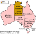
File:Australia states 1927-1931.png
外观
Australia_states_1927-1931.png (500 × 468像素,文件大小:54 KB,MIME类型:image/png)
文件历史
点击某个日期/时间查看对应时刻的文件。
| 日期/时间 | 缩略图 | 大小 | 用户 | 备注 | |
|---|---|---|---|---|---|
| 当前 | 2006年8月7日 (一) 10:39 |  | 500 × 468(54 KB) | Golbez | white background, legend |
| 2006年2月19日 (日) 03:51 |  | 500 × 468(19 KB) | Golbez | colored territories | |
| 2006年2月13日 (一) 01:09 |  | 500 × 468(19 KB) | Golbez | I got the names wrong | |
| 2006年2月13日 (一) 00:51 |  | 500 × 468(19 KB) | Golbez | Map of the states of Australia as they were between 1927 and 1931. On February 1, 1927, Northern Territory was split in two at the 20th parallel, forming Central Territory. The two were remerged on June 12, 1931. Made by User:Golbez. [[Category:Maps |
文件用途
以下页面使用本文件:
全域文件用途
以下其他wiki使用此文件:
- de.wikipedia.org上的用途
- es.wikipedia.org上的用途
- fr.wikipedia.org上的用途
- ky.wikipedia.org上的用途
- ru.wikipedia.org上的用途
- sh.wikipedia.org上的用途


