跳转到内容

英文维基 | 中文维基 | 日文维基 | 草榴社区

File:Great Lakes Lake Effect Snow 2022-11-18 1615Z.jpg

页面内容不支持其他语言。
这个文件来自维基共享资源
维基百科,自由的百科全书

原始文件 (7,698 × 6,616像素,文件大小:13.45 MB,MIME类型:image/jpeg


摘要

描述
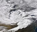
English: This true-color image of the Great Lakes region was captured in late morning hours on November 18, 2022, at 11:15 A.M. EST (16:15 UTC), by the Moderate Resolution Imaging Spectroradiometer (MODIS) instrument flying aboard NASA's Terra polar-orbiting satellite. At the time this was captured there was a polar wind blowing from the west across 50 °F (10.0 °C) waters across the Great Lakes, which resulted in multiple lake-effect snow bands forming on Lakes Michigan, Huron, Ontario, and especially on Lake Erie which brought a snow-band into the Buffalo Metropolitan Area where areas south of Downtown Buffalo saw multiple feet of snow.
日期
来源 https://worldview.earthdata.nasa.gov/
作者 NASA/Terra-MODIS

许可协议

Public domain 本文件完全由NASA创作,在美国属于公有领域。根据NASA的版权方针,NASA的材料除非另有声明否则不受版权保护。(参见Template:PD-USGov/zhNASA版权方针页面JPL图片使用方针。)
警告:

说明

添加一行文字以描述该文件所表现的内容

此文件中描述的项目

描绘内容

image/jpeg

文件历史

点击某个日期/时间查看对应时刻的文件。

日期/时间缩⁠略⁠图大小用户备注
当前2022年11月18日 (五) 22:142022年11月18日 (五) 22:14版本的缩略图7,698 × 6,616(13.45 MB)TheWxResearcherUploaded a work by NASA/Terra-MODIS from https://worldview.earthdata.nasa.gov/ with UploadWizard

以下页面使用本文件:

全域文件用途

以下其他wiki使用此文件:

元数据