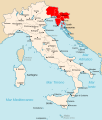
File:Litorale Adriatico.svg
外观

此SVG文件的PNG预览的大小:510 × 600像素。 其他分辨率:204 × 240像素 | 408 × 480像素 | 653 × 768像素 | 871 × 1,024像素 | 1,742 × 2,048像素 | 3,360 × 3,950像素。
原始文件 (SVG文件,尺寸为3,360 × 3,950像素,文件大小:924 KB)
文件历史
点击某个日期/时间查看对应时刻的文件。
| 日期/时间 | 缩略图 | 大小 | 用户 | 备注 | |
|---|---|---|---|---|---|
| 当前 | 2013年1月20日 (日) 14:24 |  | 3,360 × 3,950(924 KB) | Tomobe03 | Removed island of Krk from the OZAK territory per book source: Germany and the Second World War, Volume 5, By Bernhard Kroener, Rolf-Dieter Müller, Hans Umbreit; url: http://books.google.hr/books?id=3JxIMY9SVWUC isbn: 9780198208730, map on page 85 |
| 2011年6月15日 (三) 16:33 |  | 3,360 × 3,950(924 KB) | Gigillo83 | == Summary == {{Information |Description={{en|map of the Operationszone Adriatisches Küstenland in Kingdom of Italy (Regno d'Italia).}} {{it|cartina del ''Litorale Adriatico'' del Regno d'Italia nel 1942.}} |S |
文件用途
以下页面使用本文件:
全域文件用途
以下其他wiki使用此文件:
- bs.wikipedia.org上的用途
- de.wikipedia.org上的用途
- el.wikipedia.org上的用途
- en-two.iwiki.icu上的用途
- es.wikipedia.org上的用途
- fr.wikipedia.org上的用途
- hr.wikipedia.org上的用途
- id.wikipedia.org上的用途
- it.wikipedia.org上的用途
- ko.wikipedia.org上的用途
- ms.wikipedia.org上的用途
- nl.wikipedia.org上的用途
- no.wikipedia.org上的用途
- pl.wikipedia.org上的用途
- pt.wikipedia.org上的用途
- ro.wikipedia.org上的用途
- sh.wikipedia.org上的用途
- sr.wikipedia.org上的用途
- sv.wikipedia.org上的用途
- uk.wikipedia.org上的用途


