跳转到内容

英文维基 | 中文维基 | 日文维基 | 草榴社区

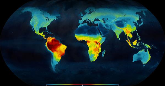
File:Map latitudinal gradient of biodiversity mannion 2014.png

页面内容不支持其他语言。
这个文件来自维基共享资源
维基百科,自由的百科全书

Map_latitudinal_gradient_of_biodiversity_mannion_2014.png (549 × 285像素,文件大小:192 KB,MIME类型:image/png


摘要

描述
English: example of latitudinal gradient of species diversity: distribution of living terrestrial vertebrate species, highest concentration of diversity shown in red in equatorial regions, declining polewards (towards the blue end of the spectrum)
Deutsch: Beispiel für den latitudinalen Biodiversitätsgradienten: Verteilung lebender terrestrischer Wirbeltierarten. Die höchste Artenzahl pro Flächeneinheit finden sich nahe dem Äquator (rote Farben), sie nimmt Richtung beider Pole ab (zunehmend blauer Farbton).
日期
来源 Palaeontology [online] (www.palaeontologyonline.com): Mannion, P. D. 2014. Patterns in Palaeontology: The latitudinal biodiversity gradient. Palaeontology Online, Volume 4, Article 3, 1-8. Map created by GLOBAÏA.
作者 Mannion, P. D., Upchurch, P., Benson, R. B. J. & Goswami, A., based on work by Clinton Jenkins

Paleontology Online publishes work under Creative Commons license. For copyright details see: http://www.palaeontologyonline.com/site-information/copyright/.

许可协议

w:zh:知识共享
署名
本文件采用知识共享署名 3.0 未本地化版本许可协议授权。
署名: Mannion, P. D. 2014. Patterns in Palaeontology: The latitudinal biodiversity gradient. Palaeontology Online, Volume 4, Article 3, 1-8.
您可以自由地:
  • 共享 – 复制、发行并传播本作品
  • 修改 – 改编作品
惟须遵守下列条件:
  • 署名 – 您必须对作品进行署名,提供授权条款的链接,并说明是否对原始内容进行了更改。您可以用任何合理的方式来署名,但不得以任何方式表明许可人认可您或您的使用。

说明

添加一行文字以描述该文件所表现的内容

此文件中描述的项目

描绘内容

image/png

196,960 字节

285 像素

549 像素

60361c4fa6654e012e759174ca5e5e5c27e3b2cc

文件历史

点击某个日期/时间查看对应时刻的文件。

日期/时间缩⁠略⁠图大小用户备注
当前2017年11月24日 (五) 23:412017年11月24日 (五) 23:41版本的缩略图549 × 285(192 KB)DeWikiMan{{Information |Description ={{en|1=example of latitudinal gradient of species diversity: distribution of living terrestrial vertebrate species, highest concentration of diversity shown in red in eq...

以下页面使用本文件:

全域文件用途

以下其他wiki使用此文件:

元数据