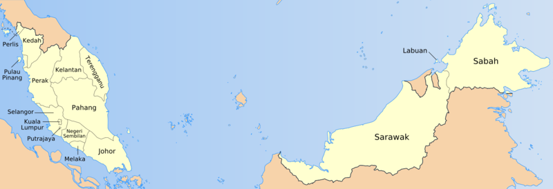
File:Malaysia states named.png
外觀

預覽大小:800 × 274 像素。 其他解析度:320 × 109 像素 | 640 × 219 像素 | 1,500 × 513 像素。
原始檔案 (1,500 × 513 像素,檔案大小:163 KB,MIME 類型:image/png)
檔案歷史
點選日期/時間以檢視該時間的檔案版本。
| 日期/時間 | 縮圖 | 尺寸 | 使用者 | 備註 | |
|---|---|---|---|---|---|
| 目前 | 2009年7月19日 (日) 10:57 | 1,500 × 513(163 KB) | Mdzafri | Corrected error in Perlis labeling and using a more detailed map. | |
| 2006年1月25日 (三) 00:44 | 1,500 × 513(34 KB) | Golbez | Better location for a couple of names. | ||
| 2006年1月24日 (二) 09:35 | 1,500 × 513(34 KB) | Golbez | Map of the states of Malaysia, named in English/local terms I think. Made by User:Golbez, based on PD CIA material, using other sources to estimate the borders of Putrajaya. Category:Maps of Malaysia |
檔案用途
下列3個頁面有用到此檔案:
全域檔案使用狀況
以下其他 wiki 使用了這個檔案:
- ace.wikipedia.org 的使用狀況
- an.wikipedia.org 的使用狀況
- ar.wikipedia.org 的使用狀況
- az.wikipedia.org 的使用狀況
- ban.wikipedia.org 的使用狀況
- bg.wikipedia.org 的使用狀況
- br.wikipedia.org 的使用狀況
- csb.wikipedia.org 的使用狀況
- cs.wikipedia.org 的使用狀況
- da.wikipedia.org 的使用狀況
- diq.wikipedia.org 的使用狀況
- el.wikipedia.org 的使用狀況
- en-two.iwiki.icu 的使用狀況
- en.wikisource.org 的使用狀況
- eu.wikipedia.org 的使用狀況
- fa.wikipedia.org 的使用狀況
- fi.wikipedia.org 的使用狀況
檢視此檔案的更多全域使用狀況。


