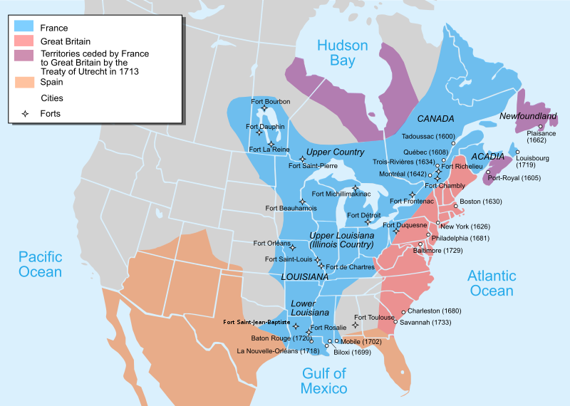
File:Nouvelle-France map-en.svg
外觀

此 SVG 檔案的 PNG 預覽的大小:800 × 570 像素。 其他解析度:320 × 228 像素 | 640 × 456 像素 | 1,024 × 730 像素 | 1,280 × 912 像素 | 2,560 × 1,824 像素 | 1,530 × 1,090 像素。
原始檔案 (SVG 檔案,表面大小:1,530 × 1,090 像素,檔案大小:586 KB)
檔案歷史
點選日期/時間以檢視該時間的檔案版本。
| 日期/時間 | 縮圖 | 尺寸 | 使用者 | 備註 | |
|---|---|---|---|---|---|
| 目前 | 2022年12月27日 (二) 22:23 |  | 1,530 × 1,090(586 KB) | Tcr25 | remove stray circle from Saskatchewan |
| 2022年12月14日 (三) 16:09 |  | 1,530 × 1,090(586 KB) | Tcr25 | plain SVG instead of Inkscape | |
| 2021年9月21日 (二) 13:24 |  | 1,530 × 1,090(590 KB) | Tcr25 | Placed Fort Rosalie in proper location; added Fort St. Jean Baptiste (Natchitoches) | |
| 2013年10月10日 (四) 14:11 |  | 1,530 × 1,090(550 KB) | Begoon | Reverted to version as of 14:02, 10 October 2013 | |
| 2013年10月10日 (四) 14:08 |  | 1,530 × 1,090(265 KB) | Begoon | revert to compare rsvg render | |
| 2013年10月10日 (四) 14:02 |  | 1,530 × 1,090(550 KB) | Begoon | revert for now - I'll play some more... | |
| 2013年10月10日 (四) 13:58 |  | 1,530 × 1,090(265 KB) | Begoon | tweak a couple of label positions | |
| 2013年10月10日 (四) 13:53 |  | 1,530 × 1,090(265 KB) | Begoon | actually - something spooky about this file ever since gradient was changed. I'm reverting to version with gradient, because it's consistent with other maps in series. Subsequent change to Fort Toulouse replicated, Mexico landmass added, layers fixed. | |
| 2013年10月10日 (四) 13:10 |  | 1,530 × 1,090(550 KB) | Begoon | cities layer is wrong - try again | |
| 2013年10月10日 (四) 11:35 |  | 1,530 × 1,090(633 KB) | Begoon | fix layers after addition |
檔案用途
沒有使用此檔案的頁面。
全域檔案使用狀況
以下其他 wiki 使用了這個檔案:
- af.wikipedia.org 的使用狀況
- an.wikipedia.org 的使用狀況
- ar.wikipedia.org 的使用狀況
- azb.wikipedia.org 的使用狀況
- az.wikipedia.org 的使用狀況
- bg.wikipedia.org 的使用狀況
- bn.wikipedia.org 的使用狀況
- bn.wikibooks.org 的使用狀況
- cs.wikipedia.org 的使用狀況
- cy.wikipedia.org 的使用狀況
- da.wikipedia.org 的使用狀況
- en-two.iwiki.icu 的使用狀況
- Canada–United States relations
- Louisiana
- Mississippi River
- French and Indian War
- European colonization of the Americas
- Louis XV
- History of the United States
- Queen Anne's War
- New France
- Peace of Utrecht
- Colonial history of the United States
- Military history of Canada
- History of Pennsylvania
- Northern Michigan
- Louisiana (New France)
- Spanish Texas
- French Americans
- United States
- History of Michigan
- Portal:Michigan
- Louisiana Creole people
- French immigration to Puerto Rico
- British America
- Canada
- History of St. Louis
- History of Louisiana
- Portal:Canada/Selected picture
檢視此檔案的更多全域使用狀況。


