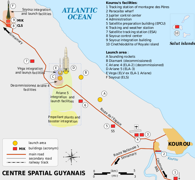
File:Plan Centre Spatial Guyanais-en.svg
外觀

此 SVG 檔案的 PNG 預覽的大小:648 × 599 像素。 其他解析度:260 × 240 像素 | 519 × 480 像素 | 831 × 768 像素 | 1,108 × 1,024 像素 | 2,215 × 2,048 像素 | 1,060 × 980 像素。
原始檔案 (SVG 檔案,表面大小:1,060 × 980 像素,檔案大小:472 KB)
檔案歷史
點選日期/時間以檢視該時間的檔案版本。
| 日期/時間 | 縮圖 | 尺寸 | 使用者 | 備註 | |
|---|---|---|---|---|---|
| 目前 | 2016年3月4日 (五) 18:08 |  | 1,060 × 980(472 KB) | Manlleus | Sorry again! |
| 2016年3月4日 (五) 18:06 |  | 1,060 × 980(524 KB) | Manlleus | Reverted to version as of 13:37, 13 April 2009 (UTC) - Sorry, was a big error! | |
| 2016年2月1日 (一) 20:51 |  | 1,060 × 980(524 KB) | Manlleus | Editing SVG source code using User:Rillke/SVGedit.js; upload handled by User:Rillke/MwJSBot.js | |
| 2009年4月13日 (一) 13:37 |  | 1,060 × 980(524 KB) | Pline | {{Information |Description={{en|1=Map of the infrastructure for the Ariane and Vega launchers at the Europe's Spaceport (Centre Spatial Guyanais or CSG) , Kourou, French Guiana}} {{fr|1=Carte des installations du Centre Spatial Guyanais (CSG) de Kourou, G |
檔案用途
下列頁面有用到此檔案:
全域檔案使用狀況
以下其他 wiki 使用了這個檔案:
- el.wikipedia.org 的使用狀況
- en-two.iwiki.icu 的使用狀況
- eo.wikipedia.org 的使用狀況
- es.wikipedia.org 的使用狀況
- et.wikipedia.org 的使用狀況
- fi.wikipedia.org 的使用狀況
- he.wikipedia.org 的使用狀況
- id.wikipedia.org 的使用狀況
- it.wikipedia.org 的使用狀況
- ja-two.iwiki.icu 的使用狀況
- kn.wikipedia.org 的使用狀況
- lv.wikipedia.org 的使用狀況
- ms.wikipedia.org 的使用狀況
- no.wikipedia.org 的使用狀況
- ro.wikipedia.org 的使用狀況
- sk.wikipedia.org 的使用狀況
- sl.wikipedia.org 的使用狀況
- sr.wikipedia.org 的使用狀況
- uk.wikipedia.org 的使用狀況
- vi.wikipedia.org 的使用狀況


