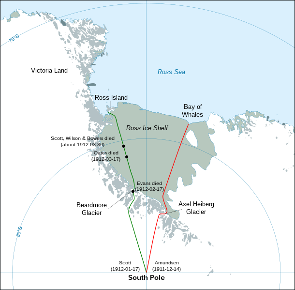
File:Antarctic expedition map (Amundsen - Scott)-en.svg
外觀

此 SVG 檔案的 PNG 預覽的大小:610 × 599 像素。 其他解析度:244 × 240 像素 | 489 × 480 像素 | 782 × 768 像素 | 1,042 × 1,024 像素 | 2,084 × 2,048 像素 | 1,898 × 1,865 像素。
原始檔案 (SVG 檔案,表面大小:1,898 × 1,865 像素,檔案大小:304 KB)
檔案歷史
點選日期/時間以檢視該時間的檔案版本。
| 日期/時間 | 縮圖 | 尺寸 | 用戶 | 備註 | |
|---|---|---|---|---|---|
| 目前 | 2023年4月29日 (六) 03:30 |  | 1,898 × 1,865(304 KB) | Pimms1 | Changed dates to YYYY-MM-DD format |
| 2010年3月6日 (六) 21:15 |  | 1,898 × 1,865(306 KB) | S.L. | revert | |
| 2010年3月6日 (六) 21:13 |  | 400 × 512(2.79 MB) | S.L. | better version, mistakes fixed | |
| 2008年3月17日 (一) 18:44 |  | 1,898 × 1,865(306 KB) | Shakki | {{Information |Description={{en|Map showing the polar journeys of the Scott's ''Terra Nova'' expedition (green) and Amundsen's expedition (red) to reach the South Pole}} {{fr|Carte montrant les parcours de l'expédition ''Terra Nova'' de Scott (vert) et c |
檔案用途
下列頁面有用到此檔案:
全域檔案使用狀況
以下其他 wiki 使用了這個檔案:
- ar.wikipedia.org 的使用狀況
- az.wikipedia.org 的使用狀況
- el.wikipedia.org 的使用狀況
- en-two.iwiki.icu 的使用狀況
- en.wikivoyage.org 的使用狀況
- es.wikipedia.org 的使用狀況
- eu.wikipedia.org 的使用狀況
- fa.wikipedia.org 的使用狀況
- fi.wikipedia.org 的使用狀況
- hu.wikipedia.org 的使用狀況
- ja-two.iwiki.icu 的使用狀況
- la.wikipedia.org 的使用狀況
- mk.wikipedia.org 的使用狀況
- nl.wikipedia.org 的使用狀況
- pl.wikipedia.org 的使用狀況
- pt.wikipedia.org 的使用狀況
- ro.wikipedia.org 的使用狀況
- simple.wikipedia.org 的使用狀況
- sr.wikipedia.org 的使用狀況


