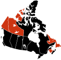
File:H1N1 Canada map.svg
外觀

此 SVG 檔案的 PNG 預覽的大小:617 × 599 像素。 其他解析度:247 × 240 像素 | 494 × 480 像素 | 791 × 768 像素 | 1,054 × 1,024 像素 | 2,108 × 2,048 像素 | 978 × 950 像素。
原始檔案 (SVG 檔案,表面大小:978 × 950 像素,檔案大小:65 KB)
檔案歷史
點選日期/時間以檢視該時間的檔案版本。
| 日期/時間 | 縮圖 | 尺寸 | 用戶 | 備註 | |
|---|---|---|---|---|---|
| 目前 | 2009年12月8日 (二) 02:47 |  | 978 × 950(65 KB) | Fonadier | First death in the Northwest Territories |
| 2009年11月24日 (二) 03:00 |  | 978 × 950(65 KB) | Fonadier | Updated to November 23, 2009 | |
| 2009年11月4日 (三) 11:49 |  | 978 × 950(70 KB) | Hariboneagle927 | first death in Labrador and Yukon | |
| 2009年10月8日 (四) 01:32 |  | 978 × 950(65 KB) | Fonadier | Fixed map | |
| 2009年8月4日 (二) 00:14 |  | 978 × 950(76 KB) | Fonadier | Deaths in Nova Scotia | |
| 2009年7月18日 (六) 23:58 |  | 978 × 950(76 KB) | Fonadier | Updated map | |
| 2009年7月17日 (五) 06:11 |  | 978 × 950(76 KB) | Vrysxy | updating | |
| 2009年7月15日 (三) 05:44 |  | 978 × 950(76 KB) | Vrysxy | Updating | |
| 2009年7月10日 (五) 00:59 |  | 978 × 950(76 KB) | Fonadier | Updated map | |
| 2009年7月9日 (四) 01:03 |  | 978 × 950(76 KB) | Fonadier | {{Information |Description={{en|1=Map showing provinces and territories reporting 2009 swine flu (H1N1) cases in Canada. <br /> {{legend|#000000|Confirmed death and infe |
檔案用途
下列頁面有用到此檔案:
全域檔案使用狀況
以下其他 wiki 使用了這個檔案:
- en-two.iwiki.icu 的使用狀況
- fr.wikipedia.org 的使用狀況
- nl.wikipedia.org 的使用狀況
- pl.wikipedia.org 的使用狀況
- vi.wikipedia.org 的使用狀況


