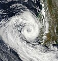
File:Izilda 25 March 2009 at 0715 UTC.jpg
外觀

預覽大小:466 × 599 像素。 其他解析度:187 × 240 像素 | 373 × 480 像素 | 597 × 768 像素 | 796 × 1,024 像素 | 1,593 × 2,048 像素 | 5,600 × 7,200 像素。
原始檔案 (5,600 × 7,200 像素,檔案大小:8.73 MB,MIME 類型:image/jpeg)
檔案歷史
點選日期/時間以檢視該時間的檔案版本。
| 日期/時間 | 縮圖 | 尺寸 | 用戶 | 備註 | |
|---|---|---|---|---|---|
| 目前 | 2009年3月26日 (四) 23:42 |  | 5,600 × 7,200(8.73 MB) | Potapych | That version is off center and clips off the storm |
| 2009年3月26日 (四) 22:08 |  | 3,843 × 4,057(3.97 MB) | HurricaneSpin | Cropped | |
| 2009年3月26日 (四) 13:24 |  | 5,600 × 7,200(8.73 MB) | Potapych | NASA images never work... | |
| 2009年3月26日 (四) 13:20 |  | 5,600 × 7,200(5.14 MB) | Potapych | {{Information |Description={{en|1=Cyclone Izilda was near its peak strength when the Moderate Resolution Imaging Spectroradiometer (MODIS) on NASA’s Terra satellite captured this image on March 25, 2009. As far as cyclones go, the comma-shaped storm was |
檔案用途
下列頁面有用到此檔案:
全域檔案使用狀況
以下其他 wiki 使用了這個檔案:
- de.wikipedia.org 的使用狀況
- en-two.iwiki.icu 的使用狀況
- es.wikipedia.org 的使用狀況
- pt.wikipedia.org 的使用狀況


