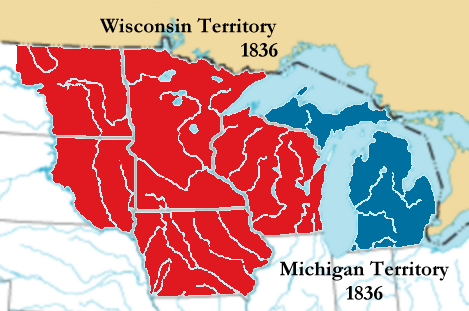
File:Michigan-territory-1836.png
外觀
Michigan-territory-1836.png (469 × 311 像素,檔案大小:85 KB,MIME 類型:image/png)
檔案歷史
點選日期/時間以檢視該時間的檔案版本。
| 日期/時間 | 縮圖 | 尺寸 | 用戶 | 備註 | |
|---|---|---|---|---|---|
| 目前 | 2008年6月30日 (一) 21:25 |  | 469 × 311(85 KB) | Thatoneguy89 | {{Information |Description=Map of en:Michigan Territory in 1836 following the detachment of Wisconsin Territory; created October 2004 by Jengod. Based on a public domain U.S. government map. |Source= English Wikipedia |Date |
| 2007年5月16日 (三) 06:35 |  | 469 × 311(85 KB) | Wars | == Summary == The image was transferred from en.wiki (en:Image:Michigan-territory-1836.png) under the '''<nowiki>{{GFDL-with-disclaimers}} + {{Cc-by-2.0-map}}</nowiki>''' license tags. ~~~~ {{Information |Description = Map of [[:en:Michi |
檔案用途
下列頁面有用到此檔案:
全域檔案使用狀況
以下其他 wiki 使用了這個檔案:
- ca.wikipedia.org 的使用狀況
- cs.wikipedia.org 的使用狀況
- de.wikipedia.org 的使用狀況
- en-two.iwiki.icu 的使用狀況
- es.wikipedia.org 的使用狀況
- fr.wikipedia.org 的使用狀況
- he.wikipedia.org 的使用狀況
- ja-two.iwiki.icu 的使用狀況
- ka.wikipedia.org 的使用狀況
- ko.wikipedia.org 的使用狀況
- no.wikipedia.org 的使用狀況
- pt.wikipedia.org 的使用狀況
- ro.wikipedia.org 的使用狀況
- ru.wikipedia.org 的使用狀況
- sv.wikipedia.org 的使用狀況
- vi.wikipedia.org 的使用狀況


