跳转到内容

英文维基 | 中文维基 | 日文维基 | 草榴社区

File:ElectoralCollege1996-Large.png

页面内容不支持其他语言。
这个文件来自维基共享资源
维基百科,自由的百科全书

原始文件 (1,182 × 635像素,文件大小:171 KB,MIME类型:image/png


U.S. presidential election maps
from the National Atlas of the United States
See also: SVG maps
1789 · 1792 · 1796 · 1800 · 1804 · 1808 · 1812 · 1816 · 1820 · 1824 · 1828 · 1832 · 1836 · 1840 · 1844 · 1848 · 1852 · 1856 · 1860 · 1864 · 1868 · 1872 · 1876 · 1880 · 1884 · 1888 · 1892 · 1896 · 1900 · 1904 · 1908 · 1912 · 1916 · 1920 · 1924 · 1928 · 1932 · 1936 · 1940 · 1944 · 1948 · 1952 · 1956 · 1960 · 1964 · 1968 · 1972 · 1976 · 1980 · 1984 · 1988 · 1992 · 1996 · 2000 · 2004 · 2008 · 2012

(this template: · view · discuss)


摘要

描述
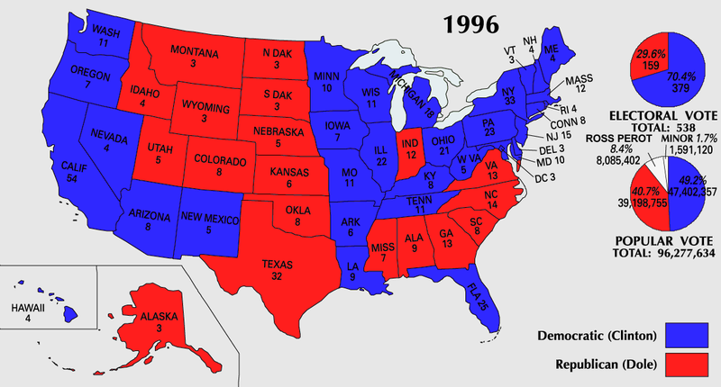
English: 1996 Electoral College Map
来源 https://nationalmap.gov/small_scale/printable/elections.html
作者 美国地质调查局
其他版本
File:ElectoralCollege1996WithPieCharts.svg是此文件的矢量版本。 如果此文件质量不低于原点阵图,就应该将这个PNG格式文件替换为此文件。

File:ElectoralCollege1996-Large.png → File:ElectoralCollege1996WithPieCharts.svg

更多信息请参阅Help:SVG/zh

其他语言
Alemannisch  العربية  беларуская (тарашкевіца)  български  বাংলা  català  нохчийн  čeština  dansk  Deutsch  Ελληνικά  English  British English  Esperanto  español  eesti  euskara  فارسی  suomi  français  Frysk  galego  Alemannisch  עברית  hrvatski  magyar  հայերեն  Bahasa Indonesia  Ido  italiano  日本語  ქართული  한국어  lietuvių  македонски  മലയാളം  Bahasa Melayu  norsk bokmål  Plattdüütsch  Nederlands  norsk nynorsk  norsk  occitan  polski  prūsiskan  português  português do Brasil  română  русский  sicilianu  Scots  slovenčina  slovenščina  српски / srpski  svenska  தமிழ்  ไทย  Türkçe  татарча / tatarça  українська  vèneto  Tiếng Việt  中文  中文(中国大陆)  中文(简体)  中文(繁體)  中文(马来西亚)  中文(新加坡)  中文(臺灣)  中文(臺灣)  +/−
新SVG图片

许可协议

Public domain
本地图取自美国国家地图集的某个版本。正如几乎所有美国联邦政府作品一样,来自国家地图集的作品在美国属于公有领域
在线访问:NationalAtlas.gov | 1970年印刷版:国会图书馆Perry-Castañeda图书馆

čeština | Deutsch | English | français | Bahasa Indonesia | italiano | македонски | മലയാളം | sicilianu | 中文 | 中文(简体)‎ | 中文(繁體)‎ | +/−

说明

添加一行文字以描述该文件所表现的内容

此文件中描述的项目

描绘内容

版权状态 简体中文(已转写)

数据大小 简体中文(已转写)

175,123 字节

635 像素

1,182 像素

媒体类型 简体中文(已转写)

image/png

校验和 简体中文(已转写)

1bccb1a928fdaab6c5e407c18970e4835659aacb

断定方法:​SHA-1 简体中文(已转写)

文件历史

点击某个日期/时间查看对应时刻的文件。

日期/时间缩⁠略⁠图大小用户备注
当前2007年7月25日 (三) 10:212007年7月25日 (三) 10:21版本的缩略图1,182 × 635(171 KB)Cardsplayer4life~commonswikiReverted to earlier revision
2007年7月25日 (三) 09:252007年7月25日 (三) 09:25版本的缩略图1,182 × 635(110 KB)Joseph Solis in Australia~commonswiki{{PD-USGov-Atlas}} Category:1996 {{US presidential election maps}}
2007年7月9日 (一) 01:482007年7月9日 (一) 01:48版本的缩略图1,182 × 635(171 KB)Cardsplayer4life~commonswiki{{PD-USGov-Atlas}} Category:1996 {{US presidential election maps}}
2007年7月6日 (五) 09:312007年7月6日 (五) 09:31版本的缩略图1,182 × 635(110 KB)Joseph Solis in Australia~commonswiki{{PD-USGov-Atlas}} Category:1996 {{US presidential election maps}}
2007年7月2日 (一) 02:302007年7月2日 (一) 02:30版本的缩略图1,182 × 635(171 KB)Cardsplayer4life~commonswiki{{PD-USGov-Atlas}} Category:1996 {{US presidential election maps}}
2007年6月29日 (五) 10:062007年6月29日 (五) 10:06版本的缩略图1,182 × 635(110 KB)Joseph Solis in Australia~commonswiki{{PD-USGov-Atlas}} Category:1996 {{US presidential election maps}}
2007年6月21日 (四) 21:022007年6月21日 (四) 21:02版本的缩略图1,182 × 635(171 KB)Cardsplayer4life~commonswiki{{PD-USGov-Atlas}} Category:1996 {{US presidential election maps}}
2006年1月22日 (日) 15:572006年1月22日 (日) 15:57版本的缩略图1,182 × 635(110 KB)Red devil 666{{PD-USGov-Atlas}}

没有页面使用本文件。

全域文件用途