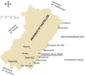
File:Main towns in the province of Castellón.png
外观

本预览的尺寸:665 × 600像素。 其他分辨率:266 × 240像素 | 532 × 480像素 | 852 × 768像素 | 1,183 × 1,067像素。
原始文件 (1,183 × 1,067像素,文件大小:200 KB,MIME类型:image/png)
文件历史
点击某个日期/时间查看对应时刻的文件。
| 日期/时间 | 缩略图 | 大小 | 用户 | 备注 | |
|---|---|---|---|---|---|
| 当前 | 2006年8月25日 (五) 17:53 |  | 1,183 × 1,067(200 KB) | Rodriguillo | Map of the '''province of Castellón''' (eastern Spain). All the towns with a population larger than 7,000 (according to 2005 official INE census) are present in the map. Made by Rodriguillo thanks to [[Castellón_-_Mapa_municipal |
文件用途
以下页面使用本文件:
全域文件用途
以下其他wiki使用此文件:
- el.wikipedia.org上的用途
- en-two.iwiki.icu上的用途
- fa.wikipedia.org上的用途
- he.wikipedia.org上的用途
- ja-two.iwiki.icu上的用途
- mk.wikipedia.org上的用途
- ms.wikipedia.org上的用途
- pam.wikipedia.org上的用途
- sco.wikipedia.org上的用途
- vi.wikipedia.org上的用途


