
File:MRT map SGJB.svg

此 SVG 檔案的 PNG 預覽的大小:800 × 457 像素。 其他解析度:320 × 183 像素 | 640 × 366 像素 | 1,024 × 585 像素 | 1,280 × 731 像素 | 2,560 × 1,462 像素 | 1,824 × 1,042 像素。
原始檔案 (SVG 檔案,表面大小:1,824 × 1,042 像素,檔案大小:213 KB)
摘要
| 描述 |
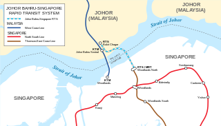
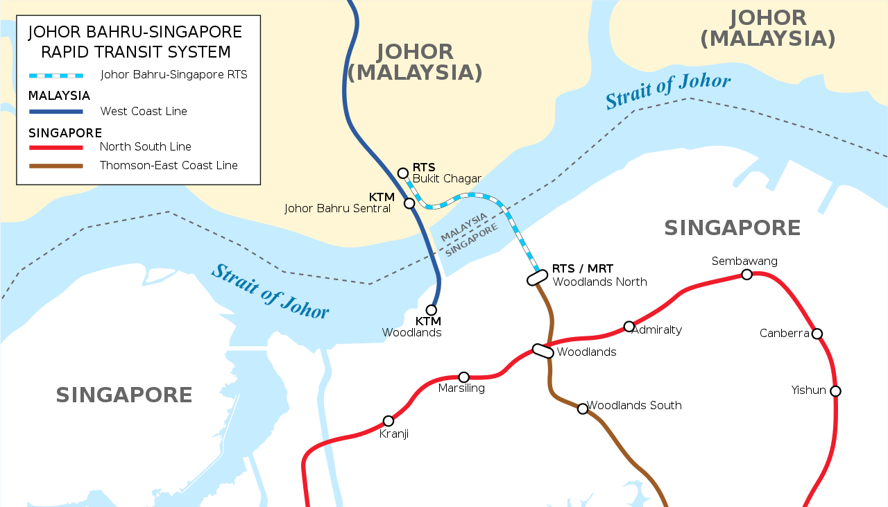
English: Map of Singapore-Johor Bahru RTS Link A variation of this map is presently printed and displayed at Singapore's RTS public information center. This map is not a copyright violation. |
| 日期 | |
| 來源 | 自己的作品 |
| 作者 | Seloloving |
授權條款
我,本作品的著作權持有者,決定用以下授權條款發佈本作品:
此檔案採用創用CC 姓名標示-相同方式分享 4.0 國際授權條款。
- 您可以自由:
- 分享 – 複製、發佈和傳播本作品
- 重新修改 – 創作演繹作品
- 惟需遵照下列條件:
- 姓名標示 – 您必須指名出正確的製作者,和提供授權條款的連結,以及表示是否有對內容上做出變更。您可以用任何合理的方式來行動,但不得以任何方式表明授權條款是對您許可或是由您所使用。
- 相同方式分享 – 如果您利用本素材進行再混合、轉換或創作,您必須基於如同原先的相同或兼容的條款,來分布您的貢獻成品。
檔案歷史
點選日期/時間以檢視該時間的檔案版本。
| 日期/時間 | 縮圖 | 尺寸 | 使用者 | 備註 | |
|---|---|---|---|---|---|
| 目前 | 2021年5月17日 (一) 11:55 | | 1,824 × 1,042(213 KB) | Seloloving | Updated map layout to be more accurate as the RTS station in SG is east of WLN. |
| 2020年2月9日 (日) 09:51 |  | 1,824 × 1,042(325 KB) | *angys* | File uploaded using svgtranslate tool (https://tools.wmflabs.org/svgtranslate/). Added translation for zh. | |
| 2020年2月9日 (日) 09:44 |  | 1,824 × 1,042(299 KB) | *angys* | File uploaded using svgtranslate tool (https://tools.wmflabs.org/svgtranslate/). Added translation for ms. | |
| 2020年1月4日 (六) 04:40 |  | 1,824 × 1,042(286 KB) | Seloloving | Added border. Fixed location of causeway. | |
| 2020年1月2日 (四) 13:08 |  | 1,823 × 1,042(288 KB) | Seloloving | Changed font. Made the map neater. Legend now reflects official name. | |
| 2018年1月16日 (二) 14:46 |  | 1,823 × 1,042(475 KB) | Seloloving | Updated map of the RTS link. | |
| 2014年8月31日 (日) 09:19 |  | 1,709 × 977(482 KB) | Seloloving | Added additional text. | |
| 2014年8月29日 (五) 11:59 |  | 1,709 × 977(569 KB) | Seloloving | Mislabeled station. | |
| 2014年8月29日 (五) 05:27 |  | 1,709 × 977(581 KB) | Seloloving | Minor edit to text. | |
| 2014年8月29日 (五) 05:18 |  | 1,709 × 977(373 KB) | Seloloving | Enlarged. |
檔案用途
下列頁面有用到此檔案:
全域檔案使用狀況
以下其他 wiki 使用了這個檔案:
- ca.wikipedia.org 的使用狀況
- en-two.iwiki.icu 的使用狀況
- fr.wikipedia.org 的使用狀況
- id.wikipedia.org 的使用狀況
- ms.wikipedia.org 的使用狀況
- www.wikidata.org 的使用狀況