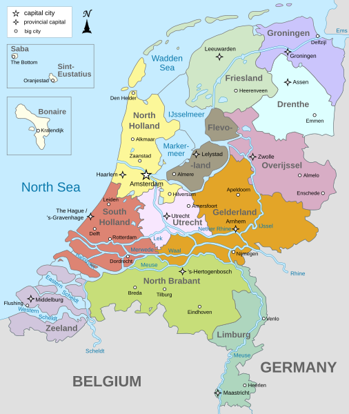
File:Map provinces Netherlands-en.svg
外觀

此 SVG 檔案的 PNG 預覽的大小:506 × 600 像素。 其他解析度:202 × 240 像素 | 405 × 480 像素 | 648 × 768 像素 | 864 × 1,024 像素 | 1,727 × 2,048 像素 | 743 × 881 像素。
原始檔案 (SVG 檔案,表面大小:743 × 881 像素,檔案大小:1,003 KB)
檔案歷史
點選日期/時間以檢視該時間的檔案版本。
| 日期/時間 | 縮圖 | 尺寸 | 使用者 | 備註 | |
|---|---|---|---|---|---|
| 目前 | 2024年1月19日 (五) 19:28 |  | 743 × 881(1,003 KB) | Illchy | File uploaded using svgtranslate tool (https://svgtranslate.toolforge.org/). Added translation for id. |
| 2023年4月29日 (六) 17:43 |  | 743 × 881(987 KB) | Dymitr | File uploaded using svgtranslate tool (https://svgtranslate.toolforge.org/). Added translation for be-tarask. | |
| 2021年11月25日 (四) 09:27 |  | 743 × 881(909 KB) | Andrei Stroe | File uploaded using svgtranslate tool (https://svgtranslate.toolforge.org/). Added translation for ro. | |
| 2019年4月12日 (五) 08:39 |  | 743 × 881(811 KB) | Thayts | Tweaked text position | |
| 2019年2月17日 (日) 11:32 |  | 743 × 881(811 KB) | Thayts | Fixed svg | |
| 2019年2月17日 (日) 11:18 |  | 743 × 881(811 KB) | Thayts | Added a bit more spacing between Eastern/Western and Scheldt | |
| 2019年2月17日 (日) 11:06 |  | 743 × 881(811 KB) | Thayts | Fixed Eastern Scheldt which wasn't rendered by the MediaWiki engine; removed Belgian city of Antwerp | |
| 2019年2月14日 (四) 05:21 |  | 743 × 881(809 KB) | Alphathon | Updated borders | |
| 2015年8月23日 (日) 20:34 |  | 743 × 881(847 KB) | Alphathon | Fixed stroke weight on a Friesland lake | |
| 2015年8月23日 (日) 20:27 |  | 743 × 881(847 KB) | Alphathon | Covered over the strokes at the mouths of rivers |
檔案用途
下列5個頁面有用到此檔案:
全域檔案使用狀況
以下其他 wiki 使用了這個檔案:
- ace.wikipedia.org 的使用狀況
- af.wikipedia.org 的使用狀況
- ang.wikipedia.org 的使用狀況
- an.wikipedia.org 的使用狀況
- ar.wikipedia.org 的使用狀況
- ay.wikipedia.org 的使用狀況
- azb.wikipedia.org 的使用狀況
- be-tarask.wikipedia.org 的使用狀況
- bg.wikipedia.org 的使用狀況
- blk.wikipedia.org 的使用狀況
- bn.wikipedia.org 的使用狀況
- ceb.wikipedia.org 的使用狀況
- diq.wikipedia.org 的使用狀況
- en-two.iwiki.icu 的使用狀況
- Netherlands
- Provinces of the Netherlands
- List of islands of the Netherlands
- King's commissioner
- Geology of the Netherlands
- File talk:Netherlands map large.png
- French war planning 1920–1940
- User talk:Gidonb/Archive 2008
- Template:Provinces of the Netherlands imagemap
- List of windmills in the Netherlands
- Provincial politics in the Netherlands
- 2008–09 KNVB Cup
- User:Alphathon/Gallery
- File talk:Netherlands Map.svg
- Portal:Islands
- Wikipedia:Reference desk/Archives/Humanities/2014 September 25
- en.wikiversity.org 的使用狀況
- eu.wikipedia.org 的使用狀況
- fa.wikipedia.org 的使用狀況
- ff.wikipedia.org 的使用狀況
- fi.wikipedia.org 的使用狀況
- fr.wikipedia.org 的使用狀況
- gl.wikipedia.org 的使用狀況
- haw.wikipedia.org 的使用狀況
- he.wikipedia.org 的使用狀況
- ia.wikipedia.org 的使用狀況
- id.wikipedia.org 的使用狀況
檢視此檔案的更多全域使用狀況。


