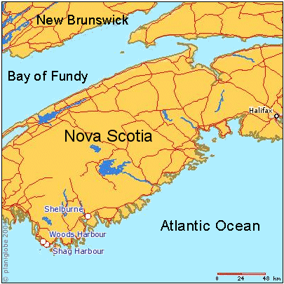
File:Shag Harbour Nova Scotia.gif
外觀
Shag_Harbour_Nova_Scotia.gif (405 × 405 像素,檔案大小:75 KB,MIME 類型:image/gif、0.1秒)
檔案歷史
點選日期/時間以檢視該時間的檔案版本。
| 日期/時間 | 縮圖 | 尺寸 | 使用者 | 備註 | |
|---|---|---|---|---|---|
| 目前 | 2011年9月13日 (二) 17:28 |  | 405 × 405(75 KB) | SreeBot | (Original text) : spelling corrections (Harbor -> Harbour) |
| 2011年9月13日 (二) 17:28 |  | 405 × 405(104 KB) | SreeBot | (Original text) : Map of southern Nova Scotia, Canada, showing location of Shag Harbour, N.S. and other locations involved in the 1967 Shag Harbour UFO incident. User-made map derived from planiform.com, under their Creative Commons Attribution 2.5 lic |
檔案用途
下列頁面有用到此檔案:
全域檔案使用狀況
以下其他 wiki 使用了這個檔案:
- en-two.iwiki.icu 的使用狀況
- fr.wikipedia.org 的使用狀況
- sr.wikipedia.org 的使用狀況
- vi.wikipedia.org 的使用狀況


