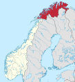
File:Troms og Finnmark in Norway 2020.svg
外觀

此 SVG 檔案的 PNG 預覽的大小:544 × 600 像素。 其他解析度:218 × 240 像素 | 435 × 480 像素 | 696 × 768 像素 | 928 × 1,024 像素 | 1,857 × 2,048 像素 | 1,361 × 1,501 像素。
原始檔案 (SVG 檔案,表面大小:1,361 × 1,501 像素,檔案大小:1.58 MB)
檔案歷史
點選日期/時間以檢視該時間的檔案版本。
| 日期/時間 | 縮圖 | 尺寸 | 使用者 | 備註 | |
|---|---|---|---|---|---|
| 目前 | 2020年11月26日 (四) 13:11 |  | 1,361 × 1,501(1.58 MB) | VulpesVulpes42 | Border correction (Tjeldsund). |
| 2019年6月22日 (六) 20:41 |  | 1,361 × 1,501(1.58 MB) | NordNordWest | corr | |
| 2019年4月30日 (二) 21:00 |  | 1,361 × 1,501(1.58 MB) | NordNordWest | corr | |
| 2019年4月22日 (一) 17:06 |  | 1,361 × 1,501(1.57 MB) | NordNordWest | corr | |
| 2019年4月21日 (日) 19:14 |  | 1,361 × 1,501(1.57 MB) | NordNordWest | == {{int:filedesc}} == {{Information |description= {{de|Lage der Provinz Troms og Finnmark in Norwegen, Stand: 1. Januar 2020}} {{en|Location of county Troms og Finnmark in Norway (2020)}} |source={{Own}} |date={{Date|2019|04|20}} |author={{U|NordNordWest}} |permission= |other_versions={{SVG locator maps (location map scheme)}} }} {{Kartenwerkstatt}} == {{int:license-header}} == {{User:NordNordWest/LicenceMap}} Category:SVG locator maps of counties in Norway (location map scheme) [[Cate... |
檔案用途
下列頁面有用到此檔案:
全域檔案使用狀況
以下其他 wiki 使用了這個檔案:
- ar.wikipedia.org 的使用狀況
- cs.wikipedia.org 的使用狀況
- da.wikipedia.org 的使用狀況
- de.wikipedia.org 的使用狀況
- el.wikipedia.org 的使用狀況
- en.wiktionary.org 的使用狀況
- eo.wikipedia.org 的使用狀況
- es.wikipedia.org 的使用狀況
- et.wikipedia.org 的使用狀況
- fa.wikipedia.org 的使用狀況
- fi.wikipedia.org 的使用狀況
- frr.wikipedia.org 的使用狀況
- fr.wikipedia.org 的使用狀況
- he.wikipedia.org 的使用狀況
- hu.wikipedia.org 的使用狀況
- it.wikipedia.org 的使用狀況
- ja-two.iwiki.icu 的使用狀況
- lv.wikipedia.org 的使用狀況
- nl.wikipedia.org 的使用狀況
- os.wikipedia.org 的使用狀況
- ro.wikipedia.org 的使用狀況
- simple.wikipedia.org 的使用狀況
- sv.wikipedia.org 的使用狀況
- vls.wikipedia.org 的使用狀況
- www.wikidata.org 的使用狀況


