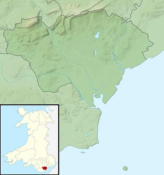
File:Cardiff UK relief location map.jpg
外观

本预览的尺寸:561 × 599像素。 其他分辨率:225 × 240像素 | 450 × 480像素 | 719 × 768像素 | 959 × 1,024像素 | 2,010 × 2,146像素。
原始文件 (2,010 × 2,146像素,文件大小:254 KB,MIME类型:image/jpeg)
文件历史
点击某个日期/时间查看对应时刻的文件。
| 日期/时间 | 缩略图 | 大小 | 用户 | 备注 | |
|---|---|---|---|---|---|
| 当前 | 2011年11月30日 (三) 00:56 |  | 2,010 × 2,146(254 KB) | Nilfanion | {{Information |Description=Relief map of Cardiff, UK. Equirectangular map projection on WGS 84 datum, with N/S stretched 160% Geographic limits: *West: 3.35W *East: 3.05W *North: 51.57N *South: 51.37N |Source=[[w:Ordnance Survey|Ordnance S |
文件用途
以下页面使用本文件:
全域文件用途
以下其他wiki使用此文件:
- ar.wikipedia.org上的用途
- ceb.wikipedia.org上的用途
- de.wikipedia.org上的用途
- el.wikipedia.org上的用途
- en-two.iwiki.icu上的用途
- St Padarn's Institute
- St Fagans Castle
- Animal Wall
- Llanishen Reservoir
- Module:Location map/data/Wales Cardiff/doc
- Lisvane Reservoir
- Bishop's Palace, Llandaff
- Wenallt Camp
- Jackson Hall, Cardiff
- Shah Jalal Mosque, Cardiff
- 6 High Street, Llandaff
- Module:Location map/data/Wales Cardiff
- Ty Bronna
- Craig-y-parc House
- Hayes Island Snack Bar
- Twmpath Castle
- Morganstown Castle Mound
- Caer Castell Camp
- St Andrew, Llandaff
- St Cross, Llandaff
- 19 High Street, Llandaff
- 2-4 High Street, Llandaff
- es.wikipedia.org上的用途
- fr.wikipedia.org上的用途
- he.wikipedia.org上的用途
- hu.wikipedia.org上的用途
- ja-two.iwiki.icu上的用途
- kn.wikipedia.org上的用途
- ko.wikipedia.org上的用途
- pl.wikipedia.org上的用途
- pl.wikibooks.org上的用途
- sh.wikipedia.org上的用途
- si.wikipedia.org上的用途
- tr.wikipedia.org上的用途
查看此文件的更多全域用途。

