马拉格塔山
外观
| 马拉格塔山 | |
|---|---|
 | |
| 最高点 | |
| 海拔 | 1,064米(3,491英尺) |
| 坐标 | 15°10′46″N 23°40′20″W / 15.17944°N 23.67222°W |
| 地理 | |
| 位置 | 圣地牙哥岛北部 |
| 地质 | |
| 岩石年代 | Miocene and Pliocene |
| 岩石类型 | basalt, basanite |
| 攀山 | |
| 最简路线 | dirt road |
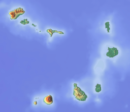
马拉格塔山(葡萄牙语:Serra Malagueta)是位于佛得角圣地亚哥北部的一座山脉,最高点海拔1064m[1],它是圣地亚哥岛北部的最高点。该山脉是马拉格塔山自然公园(Parque Natural de Serra Malagueta)的一部分,该公园成立于2005年2月24日,占地774公顷。该自然公园位于塔拉法尔县、圣米格尔县和圣卡塔琳娜县。马拉格塔山于距今290万至240万年前形成[2]。
参考文献
[编辑]- ^ Serra Malagueta Natural Park (页面存档备份,存于互联网档案馆) Pardela (葡萄牙语), accessed 2018-04-07
- ^ Holm, P. M. An 40Ar-39Ar study of the Cape Verde hot spot: temporal evolution in a semistationary plate environment. Journal of Geophysical Research: Solid Earth (J. Geophys. Res.). 2008, 113: B08201. doi:10.1029/2007JB005339.

