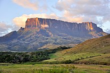
馬扎魯尼河
外觀


馬扎魯尼河是圭亞那的河流,位於該國北部,由庫尤尼-馬扎魯尼區負責管轄,屬於埃塞奎博河的一部分,河道全長560公里,發源自帕卡賴馬山脈。
外部連結
[編輯]- Mazaruni River after the rain (頁面存檔備份,存於網際網路檔案館)
- View of lower Roraima Plateau (頁面存檔備份,存於網際網路檔案館)
- Aruwai Falls (頁面存檔備份,存於網際網路檔案館)
- Diamond dredges on Kurupung River, Mazaruni River Basin (頁面存檔備份,存於網際網路檔案館)
- Gold and diamond mining above Aruwai Falls, Mazaruni River (頁面存檔備份,存於網際網路檔案館)
- Piray, the example of piranha related fish common in Mazaruni River (頁面存檔備份,存於網際網路檔案館)
- Preston King documentary film on portknoking in Guyana, ca. 1993 (頁面存檔備份,存於網際網路檔案館)
6°25′N 58°38′W / 6.417°N 58.633°W
| 這是一篇與圭亞那地理相關的小作品。您可以透過編輯或修訂擴充其內容。 |
